Terrestrial Water Cycle Changes
High Mountain Asia (HMA), a region that includes the Tibetan Plateau and the Himalayan, Karakoram, Pamir, Hindu Kush, and Tien Shan mountains, represents the headwaters of Asia's most prominent hydrologic basins, which feed billions of people. HMA is subject to warming at an alarming rate in addition to an intense human management. During HiMAT 2, our team developed a terrestrial water cycle reanalysis with the best available, downscaled meteorology conditions, a state-of-the-art land surface model, a large suite of remote sensing measurements, and advanced data assimilation algorithms to better understand the impacts of a changing climate and human management on land surface processes and subsurface hydrology in HMA.
High-quality precipitation datasets are critical for land surface modeling. Nonetheless, precipitation is highly uncertain especially in complex environments such as HMA where it remains extremely hard to measure due to the harshness of the area. As a result, in HMA, gridded precipitation products provide different values of precipitation and trends which make hydrologic analyses difficult. Because different gridded precipitation products have different performance and accuracy depending on the area over HMA and there is not an overall best and accurate dataset for the region, we generated an ensemble precipitation with GPM IMERG, CHIRPS, and ERA5 datasets using a localized probability matching mean method1. Comparisons between the ensemble product and the selected ensemble members have shown that the ensemble allows filtering out inconsistencies and differences across the different products and provides more realistic datasets.
HMA exhibits high increases in vegetation greenness. While Earth’s greening has been attributed to climate change in general, greening over HMA has potentially multiple drivers because of the complexity of the environment. We performed a holistic multivariate remote sensing analysis which simultaneously examines the primary components of the terrestrial water cycle from 2003 to 2020 to identify the main drivers of greening in the region2. Our analysis showed that (1) precipitation drives greening in mid and low elevation areas covered by evergreen and mixed forests (e.g., Yangtze basin), (2) warming and decreases in snow enhance greening in areas where the cryospheric processes are important, and (3) irrigation induces greening in irrigated lands (Ganges-Brahmaputra and Indus).
Changes in vegetation greenness impact the surface albedo, which can further exacerbate/counterbalance the impacts of climate change. We performed a remote sensing analysis to quantify the changes in surface albedo and their drivers over HMA3. Our results demonstrate that greening dominates the changes in surface albedo in vegetated areas. However, in vegetated areas subject to cryospheric processes, the changes in snow cover are the dominant driver to the changes in surface albedo in winter, the effects of vegetation greenness are only preponderant from spring to fall. Soil moisture drives the decreases in surface albedo in non-vegetated areas with low fractional snow cover. Over the irrigated lands of HMA, both changes in vegetation and soil moisture control the high decreases in surface albedo due to the induced greening and high soil moisture.
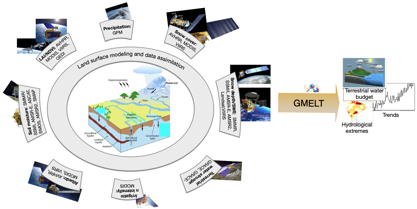
The HMA’s land reanalysis is based on a multivariate assimilation of remotely sensed estimates of irrigation, GRACE GSFC’s Terrestrial Water Storage (TWS), MODIS’s leaf area index (LAI), snow water equivalent (SWE) derived from MODIS, and ESA CCI’s soil moisture into the land surface model Noah-Multi-Parameterization (Noah-MP) from 2003 to 20207. To simulate the surface water dynamics, including streamflow, we use the Hydrological Modeling and Analysis Platform (HyMAP), a state-of-the-art, globalscale flood model. The land reanalysis has been validated by comparing the trends in simulated key hydrologic variables such as streamflow, runoff and groundwater storage, and evapotranspiration to the trends derived from ground (streamflow and groundwater levels) and remotely sensed (the global runoff data, MODIS evapotranspiration and the Global Land Evaporation Amsterdam Model (GLEAM) evapotranspiration) measurements7. We also evaluate the probability of snow detection of the reanalysis. The HMA reanalysis with a spatial resolution of 5 km and a temporal resolution of a day provides spatially and temporally consistent estimates of storages, fluxes, and meteorological conditions that are relevant for a range of model applications in hydrology. The reanalysis is conducted using the NASA Land Information System (LIS), an advanced land surface modeling and data assimilation environment. The datasets are currently available at the National Snow and Ice Dataset Center (NSIDC).
With the onset of climate change, mountainous regions such as HMA are subject to rain-on-snow with dramatic consequences on downstream hydrology. We analyzed rain-on-snow events and their trends over the past two decades in HMA using the developed model4. The results showed that rain-on-snow significantly contributes to runoff in the region and are characterized by bidirectional trends with strong implications for water management5. For instance, the decreasing trends of rain-on-snow in some of areas of HMA (e.g., over the Ganges-Brahmaputra basin) will have consequences of decreased recharge from the headwaters and exacerbated use of groundwater unless increasing trends of rainfall compensate for the decreasing snowmelt whereas the increasing trends in Indus contribute to reducing the snowpack in late summer, with concerns of reduced water availability and increased groundwater exploitation for agricultural purposes.
The renalysis was also used to better understand the impacts of irrigation-driven groundwater depletion in the Ganges-Brahmaputra on the streamflow in the Bay of Benghal, which has a crucial role in global geopolitics and Southeast Asia’s economy6. The effects of such activities mostly occurring in the Ganges basin, either intensified or lessened depending on the area by the climatic conditions, decrease the streamflow in the bay by up to 1200 m3/s/year. While the increase in precipitation in the Ganges basin reduces the effects of irrigation-driven groundwater depletion on the streamflow, the decrease in precipitation and the snowmelt decline in the Brahmaputra basin exacerbate streamflow reduction due to groundwater depletion at the basin’s delta.
In a follow-up study, we focus on two HMA basins (the Yangtze and the Ganges-Brahmaputra) to contrast the impacts of climate- and human-induced greening on evapotranspiration using the land reanalysis5. Greening can alter the water and energy cycles by changing the evapotranspiration. We found that though the rate of greening is similar in both basins, anthropogenic influences lead to dissimilar responses in evapotranspiration. In the Yangtze, climate-induced greening increases evapotranspiration, with the increase in moisture being high enough to meet the evapotranspiration demand. In the Ganges-Brahmaputra, irrigation-induced greening does not alter annual evapotranspiration, only pre-monsoon evapotranspiration increases. The dry season declines in water storage due to pumping decrease evapotranspiration, while laboriously meeting the demand.
References
Maina, F. Z., Kumar, S. V., Dollan, I. J., & Maggioni, V. 2022 “Development and evaluation of ensemble consensus precipitation estimates over High Mountain Asia”↩
Maina, F.Z., Kumar, S. V., Albergel, C., Mahanama S. P. 2022 “Warming, increase in precipitation, and irrigation enhance greening in High Mountain Asia”↩
Maina, F. Z., Kumar, S. V., & Gangodagamage, C. 2022 “Irrigation and warming drive the decreases in surface albedo over High Mountain Asia”↩
Maina, F. Z., Kumar S. V. 2023 “Diverging trends in rain-on-snow over High Mountain Asia”↩
Maina, F., et al. “Anthropogenic influences alter the response and seasonality of evapotranspiration: A case study over two High Mountain Asia basins”, Geophysical Research Letters, Accepted.↩
Maina F. Z., Getirana A., Kumar S.V., Saharia M., Kumar B. N., McLarty S., Appana R. “Irrigation-driven groundwater depletion in the Ganges-Brahmaputra basin decreases the streamflow in the Bay of Bengal”, Communication Earth Environment, In review.↩